World 01 · interactive
La Manga del Mar Menor in 3D
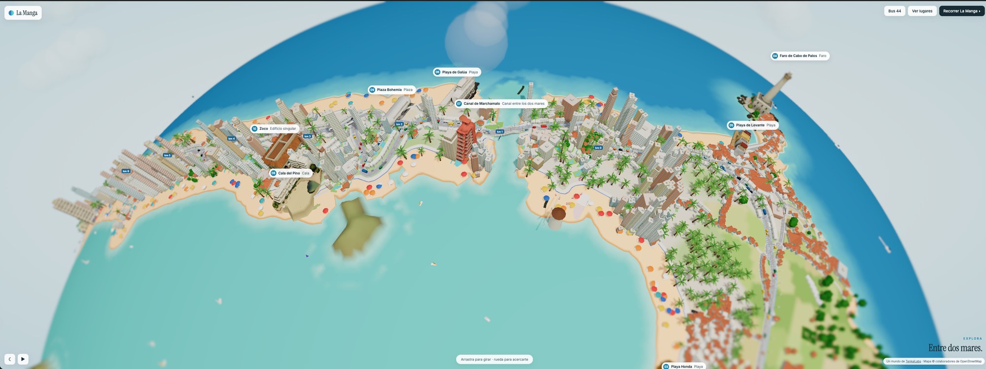
We turned La Manga del Mar Menor, in Murcia (Spain), into a small planet you can turn and explore in your browser, with its beaches, the Gran Vía and the channels that join the Mar Menor lagoon to the Mediterranean.
What's inside
- The 16 places of a route from south to north, each with its 3D model and its card. Tap one and the buildings around it move aside so you can see it whole.
- The Gran Vía with its kilometre posts, the cars and bus line 44, which runs to its timetable.
- A guided tour of La Manga and the change from day to night.
The 16 places
- Campo de golf Golf
Golf courses at the foot of the hills, next to Los Belones, a few minutes from the entrance to La Manga. - Los Belones Village
A village of the Campo de Cartagena at the gateway to La Manga, on the way between the golf course and Cabo de Palos. - Playa Honda Beach · Mar Menor
On the shore of the Mar Menor, with calm, shallow beaches. - Faro de Cabo de Palos Lighthouse · km 0
Lit in 1865, it marks the southern end of La Manga. The Cabo de Palos and Islas Hormigas marine reserve starts at its foot. - Playa de Levante Beach · Mediterranean
The Cabo de Palos beach that faces the Mediterranean, next to the harbour and the fishing village. - Playa de Galúa Beach
One of the beaches along the first kilometres of the Gran Vía, at the start of La Manga. - Canal de Marchamalo Channel between the two seas
One of the golas, the channels that join the Mar Menor to the Mediterranean, next to the old Marchamalo salt pans. - Cala del Pino Cove · Mar Menor
A calm Mar Menor cove on the southern stretch of La Manga. - Plaza Bohemia Square
A square by the Gran Vía, one of La Manga's meeting points. - Zoco Landmark building
A building with an Arab look and a kasbah tower, one of the most recognisable on the Gran Vía. - Pedruchillo Stretch of La Manga
The central stretch of La Manga, between the Mar Menor beaches and the Mediterranean ones. - Puente del Estacio Drawbridge
It crosses the El Estacio gola, the passage between the Mar Menor and the Mediterranean, and opens to let boats through. - Faro del Estacio Lighthouse
It marks the entrance to the El Estacio channel for boats coming from the Mediterranean. - Puerto Tomás Maestre Marina
La Manga's large marina, open to both seas through the El Estacio channel. - Puente de la Risa Bridge · Veneziola
A bridge in Veneziola over one of the golas between the two seas, in the north of La Manga. - Veneziola Canals
At the northern end of the strip, houses between canals where La Manga narrows towards the encañizadas.
How it is made
The terrain, the streets, the buildings, the palm trees and the traffic are programmed with three.js from OpenStreetMap data. The models of the places start from real photographs: an AI image model turns each photo into a scale model and TRELLIS.2 makes it 3D.
The models are AI-generated. The idea and the direction are ours. It is a work in progress and we keep adding to it.
Credits
Map data © OpenStreetMap contributors, under the ODbL licence.
Reference photographs from Wikimedia Commons for the models:
- Campo de golf: photo by LMC123, CC BY-SA 4.0
- Los Belones: photo by Maciej Lewandowski, CC BY-SA 2.0
- Playa Honda: photo by INDALOMANIA, CC BY-SA 3.0
- Faro de Cabo de Palos: photo by Diego Delso, CC BY-SA 4.0
- Playa de Levante: photo by I HQ from Cabo de Palos, España, CC BY-SA 2.0
- Playa de Galúa: photo by P4K1T0, CC BY-SA 4.0
- Canal de Marchamalo: photo by V & A, CC BY 3.0
- Cala del Pino: photo by P4K1T0, CC BY-SA 4.0
- Plaza Bohemia: photo by P4K1T0, CC BY-SA 4.0
- Zoco: photo by P4K1T0, CC BY-SA 4.0
- Pedruchillo: photo by Felipe Ortega, CC BY-SA 2.0
- Puente del Estacio: photo by Werner Wilmes, CC BY 2.0
- Faro del Estacio: photo by Aureliano from Castellón, España, CC BY-SA 2.0
- Puerto Tomás Maestre: photo by Bernardo Reis, CC BY-SA 3.0
- Puente de la Risa: photo by amaianos, CC BY 2.0
- Veneziola: photo by Concepcion AMAT ORTA…, CC BY 3.0


